We want to understand local economic conditions, so we need to define what it means to be “local.” We’re especially interested in local labor markets, so we’re thinking from the perspective of workers and employers. The goal is to define geographics areas which encompass most of the jobs a person would seek and candidates an employer would look for. Then things like wages and the number of jobs will be set by conditions in that geographic area.
Most of the data is available for individual counties, but that’s usually too narrow. People often live in one county and work in another, so it doesn’t make sense to think of each county as a separate local labor market. Consequently, we use commuting zones (CZs). CZs are groups of counties (and sometimes single counties) chosen based on commuting data; there is a lot of commuting among counties within a CZ and not much between CZs. So, they suit our goal nicely. The 741 CZs were initially defined by the U.S. Department of Agriculture and have since been used by many people for academic research and policy analysis (for example, recent research indicates that CZs are a better definition of local labor markets than counties). The boundaries of the CZs are show in the map below.
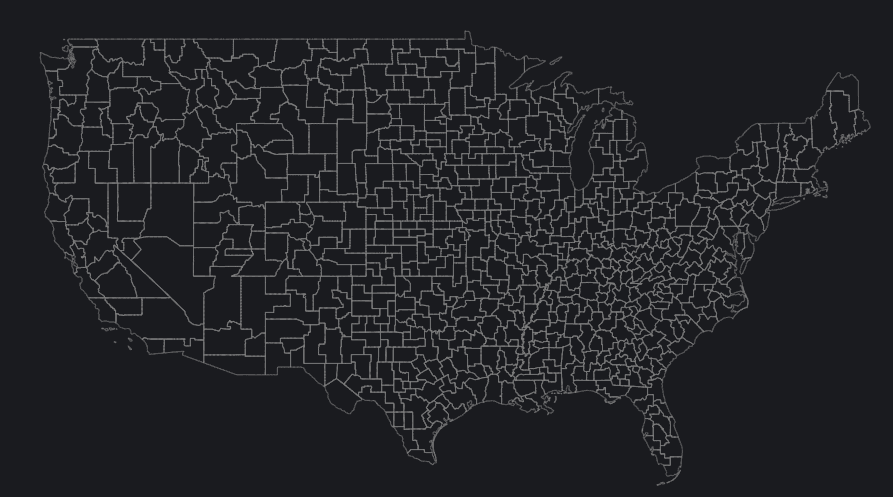
CZs are highly varied. Some contain many counties and cross state borders, and others are just single counties. The smallest CZs have working age populations in the hundreds, while the largest have millions (this is why we report many statistics on a per capita basis). Some of the differences between CZs reflect notable economic disparities. In 2021, average annual incomes for full-time workers were between $30,000 and $35,000 in the poorest CZs and over $70,000 in the richest.

However, there is no perfect measure of “locality” and using CZs has some drawbacks. For example, we use the CZs defined in 1990 for consistency across all the years in our data, but this covers more than 40 years, so we may miss some changes in commuting patterns. Also, the commuting data in some areas is sparse, so the boundaries of densely populated urban areas may be more accurate than in rural areas.
That said, CZs have proven to be a useful concept: large enough to include most people’s economic lives, but small enough to capture important local differences.